
Producing a Transit Map by Using Cell Phone Data
IDSS PI: Sarah Williams
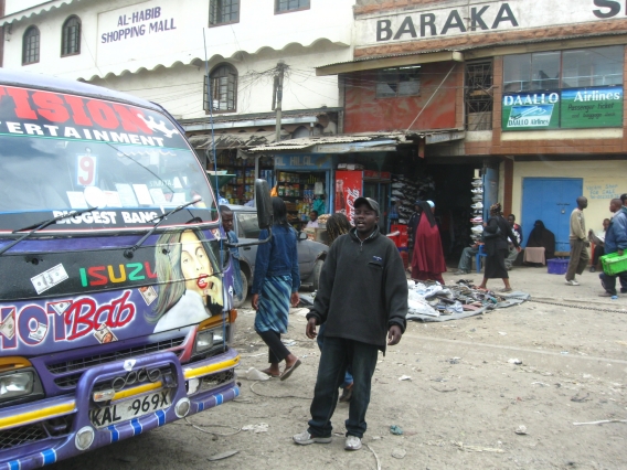
The Digital Matatus project is a novel research project in Nairobi, Kenya. As part of a joint effort involving MIT, Columbia University, the University of Nairobi, and Groupshot Design Consultancy, Digital Matatus deployed Kenyan researchers equipped with smartphones to collect and analyze data from the network of matatus—privately owned minivans—that services the Kenyan capital. The open-source data were transformed into a popular paper map and are now searchable in Google Maps as a transit option.
semi-formal mini-buses (paratransit). However, little to no digital information is typically available on routes, bus stops, passenger boarding, service frequency or scheduled trip times. Cities that rely on these bus systems can benefit from the generation of digital data on these systems for planning and passenger information purposes. Perhaps more importantly, this data can provide the ability to generate citizen-based information tools, such as transit routing applications for mobile devices widely discussed in the smart cities dialog (Townsend in Re-Programming Mobility, The Digital Transformation of Transportation in the United States, 2014). This work in Nairobi shows that cell-phone technology that is ubiquitous in most countries can be used to generate a dataset in an open standard, GTFS. Citizens can then leverage open source tools made for that standard, enhancing access to information about the transit system. One of the most important components of this work in Nairobi was the engagement process that created trust in the data and knowledge of its existence for the development of civic technologies. The lessons learned in Nairobi can be translated to other areas with the potential to use mobile applications to develop data on essential urban infrastructure and to extend the use of that data by sharing it with a larger community.
References and Related Content:
“Leveraging Cellphones for Wayfinding and Journey Planning in Semi-formal Bus Systems: Lessons from Digital Matatus in Nairobi” – chapter 12, Planning Support Systems and Smart Cities
“Digital Matatus project makes the invisible visible” – MIT News
“How Nairobi Got Its Ad-hoc Bus System on Google Maps” – WIRED